by Calimlim, Noli R.
2013-11406
Last July 2012, President Benigno
Aquino III called the attention of powerful agencies to perform actions and to
help put into place the prevention of hardships, caused by typhoons and floods,
experienced by most of the Filipino people. As a response, the Department of
Science and Technology (DOST) launched a project called Nationwide Operational
Assessment of Hazards, also known as Project NOAH, which aims to mitigate disasters
through the use of advanced technology like stream and rain gauges and to make
people aware ahead of time whenever a bad weather is approaching the country.
(“About Project NOAH”)

Project
NOAH MTSAT image as of August 7, 2013, 10:01 AM. Screengrab from http://noah.dost.gov.ph/
NOAH also exhibits useful features, tools and components
that can contribute for a more accurate and responsive disaster prevention like
the installation of state-of-the-art instruments. One of the most important
aspects of these features is the creation of flood maps which displays the most
flood-affected areas and the safer grounds. (Dungo, 2012)
In line with the opening of the National Science and
Technology Week (July 23), dubbed 2013 Expo Science in Pasay City, DOST has
activated at least 500 flood sensors and rain gauges nationwide. Aside from
these sensors installed in 18 major river basins nationwide, another 500
sensors are to be distributed to local government units upon their request. (“DOST activates rain gauges, flood sensors”) On the same event, DOST, through Project NOAH, has come up
with a tablet device aptly called Moses (Mobile Operational System for
Emergency Services).
Moses is an 8-inch mobile tablet capable of receiving
real-time weather and flood information reports from the DOST’s Philippine
Atmospheric, Geophysical and Astronomical Services Administration (Pagasa) and
Project NOAH. The DOST aims to provide the 42,028 barangays with this tablets.
For the pilot test, 1,000 units will be distributed to different barangays in
Metro Manila. Moses also provides Doppler radar sensor data, water-level sensor
data and measurements culled from gauges strategically located in different
high-risk areas. Also available in the tablet is a hazard map that is updated
in real time. (S&T Media Services, 2013)
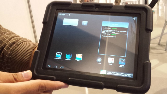
The Moses
tablet. Photo by Kim Luces
The
accurate information can be accessed by local officials, down to the barangay
level, in order to aid them in their decision-making to prevent the loss of
life and property.
Last 20th
of September, Rappler formalizes
its parnership with Weather Philippines and Project NOAH, to further strengthen
its weather and disaster news coverage in line with its aim for a better, more
accurate weather and disaster news for the public. (Rappler, 2013)
Mahar Lagmay, director of DOST- Project NOAH said
that they welcome this agreement with Rappler, because he know that media can
help a lot in disseminating crucial, vital and understandable information.
Information that all of the people need in the far-flung areas and even in the
cities in order for them to save themselves.
Works Cited
"About Project NOAH." Official Gazette of the
Republic of the Philippines. N.p., 06 July 2012. Web. 07 Mar. 2014.
<http://www.gov.ph/ >.
"DOST Activates Rain Gauges, Flood Sensors." Solar
News. N.p., 25 July 2013. Web. 07 Mar. 2014. <http://www.solarnews.ph/
>.
Dungo, Fehl. "DOST Project for Flood, Rain and Weather
Assessment." PhilPad RSS. N.p., 2012. Web. 07 Mar. 2014.
<http://philpad.com/ >.
Rappler.com. "Rappler Signs MOA with Weather Philippines,
Project Noah." Online posting. Rappler. N.p., 09 Sept. 2013.
Web. 07 Mar. 2014. <http://www.rappler.com/ >.
S & T Media Services. "Moses Tablet Unveiled for Disaster
Preparedness." Science.ph. N.p., 01 Aug. 2013. Web. 07 Mar. 2014. <http://www.science.ph/ >.
Walang komento:
Mag-post ng isang Komento